Wales Snowdonia National Park Trails
Discovering the Snowdonia National Park trails offers a direct path into the heart of Wales’s most dramatic and ancient landscapes. These routes range from the iconic ascent of Yr Wyddfa (Snowdon) to serene valley walks and coastal paths, each revealing a different facet of the park’s 823 square miles. This guide provides essential route descriptions, logistical advice for planning your journey, and insights into the natural and cultural history that shapes every footstep, helping you select the perfect path for your ability and ambition.
Essential Park and Trail Information
Snowdonia National Park, or ‘Parc Cenedlaethol Eryri’ in Welsh, was established in 1951 as Wales’s first national park. It encompasses not just mountains but also deep river gorges, expansive forests, historic castles, and 37 miles of coastline. The landscape was sculpted by volcanic activity and millennia of glaciation, creating the rugged terrain that defines its character and its legendary hiking routes.
Navigating this terrain requires understanding the classification of its paths. The park’s management categorizes trails to help hikers make informed decisions about difficulty. Always check the official park website for real-time alerts on path closures, weather warnings, or conservation work before you set out, as conditions can change rapidly in this mountainous region.
Understanding Trail Classifications
Trails are graded to manage expectations and ensure safety for all visitors.
- Easy (Green): Well-defined, mostly flat paths suitable for families and casual walkers, like the Mawddach Trail or the circuit around Llyn Padarn. These often have accessible surfaces and minimal elevation gain.
- Moderate (Blue): Involving steady inclines and potentially rougher ground, these routes like the Precipice Walk or the ascent of Cadair Idris via the Pony Path require decent fitness and sturdy footwear.
- Strenuous (Red): Challenging mountain paths with significant ascents, rough terrain, and possible scrambling sections. The Snowdon Ranger Path and the Glyderau traverse fall into this demanding category, requiring good navigation skills.
- Expert (Black): These are for experienced hillwalkers only and involve exposure, serious scrambling, or climbing. The Crib Goch ridge on Snowdon is the prime example, where a head for heights and proper equipment are non-negotiable.
- Budget Hiker ($40-70/day): Focus on free trails, wild camping (where permitted), and self-catering. Use public transport like the Sherpa’r Wyddfa bus network ($6-10 per day ticket). Stay in basic hostels or bothies, and pack all food. Parking is your biggest potential cost, so aim for free roadside spots or use park-and-ride.
- Mid-Range Hiker ($100-180/day): This allows for B&B or hotel stays in villages like Betws-y-Coed or Beddgelert, meals at local pubs, and guided walks for specific skills or routes ($45-75 per person). You can afford paid parking at major trailheads and the occasional use of taxis for linear walks.
- Luxury Hiker ($250+/day): Includes stays in high-end hotels or guided multi-day touring packages. Enjoy fine dining, private transport for door-to-trailhead service, and bespoke guiding from accredited Mountain Leaders for exclusive, off-the-beaten-path experiences across the entire national park.
- Snowdonia National Park Authority
- Ordnance Survey (OS Maps)
- Mountain Bothies Association
Key Details on Park Access and Conservation
Access to the park is free, but there are costs for specific services like the park-and-ride schemes, mountain railway tickets, and parking at popular trailheads. The park operates a ‘PayOnce’ parking system at major sites like Pen-y-Pass, where your fee is valid for the day across multiple car parks. Proceeds directly fund path maintenance and conservation projects.
Respect for the environment is paramount. The park authority actively promotes the ‘Leave No Trace’ principles. Stick to marked paths to prevent erosion, take all litter home, and keep dogs under close control, especially during the lambing season from spring to early summer. Your cooperation helps preserve these landscapes for future generations of hikers.
The Role of Mountain Huts and Bothies
For multi-day trekkers, the park offers several basic shelters. The most famous is the summit cafe on Snowdon, Hafod Eryri, which is only accessible via foot or train. For true wilderness stays, the Mountain Bothies Association maintains simple, unlocked shelters like the one in Cwm Penlledar. These are free to use but offer no facilities; you must carry in all supplies and carry out all waste.
Alt: “snowdonia-national-park-mountain-trail-panoramic-view-hiker”
Wales Snowdonia National Park Trails – Planning Your Trip
Successfully exploring the Snowdonia National Park trails hinges on thoughtful preparation centered around weather, timing, and personal fitness. The region’s climate is famously changeable, with conditions on the summits differing drastically from those in the valleys, often experiencing stronger winds and lower temperatures. Planning involves more than picking a route; it’s about building a flexible itinerary that prioritizes safety and enjoyment over simply ticking off a peak.
Your choice of route should align with your group’s least experienced member. Overestimating ability is the most common cause of mountain rescue call-outs here. Consider splitting a challenging goal, like Snowdon, over two days or selecting one of its six main paths that matches your comfort level, rather than opting for the most direct ascent. Booking accommodation and parking well in advance is non-negotiable for summer and weekend visits.
Best Time to Hike Snowdonia Trails
The optimal window for hiking in Snowdonia is from late May to late September. During these months, you’ll experience longer daylight hours (up to 16 hours in June), milder temperatures averaging 59-68°F (15-20°C) in valleys, and generally more stable weather. The trails are at their driest, reducing slip hazards on rocky paths, and all mountain services, including the Snowdon Mountain Railway, operate regularly.
Shoulder seasons in April-May and October offer fewer crowds and vibrant landscapes—spring blooms or autumn colors—but demand greater preparedness for colder, wetter conditions, with valley temperatures between 46-59°F (8-15°C). Winter hiking, from November to March, is for experienced mountaineers only, requiring ice axes, crampons, and full winter navigation skills as temperatures on summits frequently drop below freezing, often between 23-32°F (-5 to 0°C).
Budget Planning and Costs
Costs can vary significantly based on your hiking style and duration.
Essential Preparation Checklist
Never underestimate the mountain environment. Your pack must include the essentials: a detailed map (OS Explorer OL17/OL18) and compass, a headtorch, extra food and water, waterproof and insulated layers, a first-aid kit, a whistle, and a charged mobile phone with the What3Words app. Footwear should be worn-in, ankle-supporting hiking boots with a good grip, not trainers.
Check your travel insurance covers mountain hiking and potential rescue. EU and US passport holders do not need a visa for tourist visits to the UK under 6 months. Inform someone of your planned route and expected return time. Finally, download the ‘Snowdonia National Park’ app for offline maps, weather forecasts, and the latest trail updates before you lose signal.
Top Trails and Hiking Experiences
The park’s network of paths caters to every aspiration, from conquering the highest peak in Wales to discovering secluded waterfalls. Each major route possesses a distinct character, shaped by history and geology. The Llanberis Path, for instance, follows the old railway workmen’s track, while the Miners’ Track passes by the remnants of the area’s industrial past, blending natural beauty with human history in a single walk.
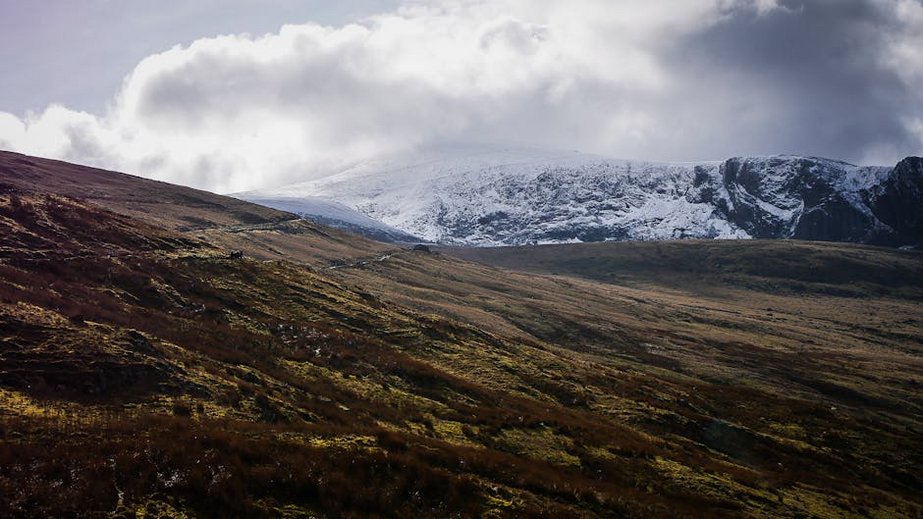
Beyond Snowdon itself, the park boasts other magnificent massifs like the Glyderau, with its bizarre rock formations, and the Carneddau, the largest continuous area of high ground in England and Wales. Coastal paths around Barmouth or Harlech offer dramatically different vistas where mountains meet the sea. Balancing your itinerary between famous climbs and quieter discoveries provides the most complete experience of Eryri.
Must-See Highlights and Iconic Ascents
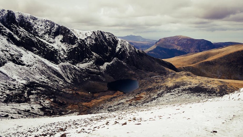
The Pyg Track and Miners’ Track are the most popular routes to Snowdon’s summit, starting from Pen-y-Pass. They offer spectacular views of the glacial lakes, Llyn Llydaw and Glaslyn, but can be extremely crowded. For a longer but quieter ascent with a sense of history, the Snowdon Ranger Path, the oldest route, begins near Llyn Cwellyn. Summit tickets for the historic mountain railway start at $45 round-trip for adults if you prefer to save your legs for the descent.
Cadair Idris, the legendary ‘Chair of Idris,’ presents a formidable challenge via the Fox’s Path or a more gradual climb on the Pony Path from Dolgellau. Its summit ridge overlooking Llyn Cau is one of Wales’s most awe-inspiring sights. For unique geology, the hike to the summit of Tryfan, involving Grade 1 scrambles like the famous ‘Adam and Eve’ rocks, is a rite of passage for UK scramblers. Parking at these trailheads typically costs $6-10 for the day.
Hidden Gems and Quieter Alternatives
To escape the crowds on Snowdon, explore the Nantlle Ridge. This demanding horseshoe walk delivers sensational views of the Snowdon massif without the queues, featuring eight peaks including Mynydd Drws-y-Coed. Similarly, the Mawddach Estuary Trail from Dolgellau to Barmouth is a flat, family-friendly walk on a disused railway line, offering breathtaking sunsets over the estuary with the mountains as a backdrop.
Discover the ‘Welsh Whisky’ of waterfalls in the lesser-visited Coed-y-Brenin forest. The Puppy Trail here is a manageable loop leading to multiple cascades. For a true sense of wilderness, the Rhinogydd range in the park’s south offers rough, pathless terrain and ancient stone circles, rarely visited even in peak season. These areas require confident navigation but reward with profound solitude.
Family-Friendly and Accessible Paths
Not all adventures here are grueling climbs. The Swallow Falls walk near Betws-y-Coed is a short, paved path to a powerful waterfall (small entry fee applies). The Llyn Geirionydd trail from Trefriw is a gentle lakeside loop perfect for young children. For accessibility, the dedicated All Ability Trail at Coed y Garth, near Bangor, and the firm-surfaced path around Llyn Padarn in Llanberis provide stunning views and are suitable for wheelchairs and strollers.
Practical Travel and Logistics
Reaching Snowdonia is straightforward, with excellent road and rail links. The primary gateway is the A55 North Wales Expressway, connecting to the M56/M6 from England. Major train stations include Bangor on the coastal main line and Llandudno Junction, with the picturesque Conwy Valley line running into the heart of the park to Blaenau Ffestiniog. Once within the park, a car offers flexibility, but the dedicated Sherpa’r Wyddfa bus service is a superb, sustainable way to access major trailheads without parking hassles.
Accommodation ranges from rustic campsites and shepherd’s huts to luxury country house hotels. Key towns to base yourself in include Betws-y-Coed (the “gateway village”), Beddgelert (central and scenic), Llanberis (for Snowdon access), and Dolgellau (for southern ranges). Booking is essential months in advance for summer and holiday periods, as options in small villages are limited.
| Accommodation Type | Features & Best For | Price Range (USD/Night) |
|---|---|---|
| Campsites & Pods | Basic facilities, stunning locations, direct trail access. Best for budget and flexible hikers. | $15 – $45 |
| Hostels & Bunkhouses | Shared dorms or rooms, communal kitchens, social atmosphere. Ideal for solo travelers and groups. | $30 – $70 |
| Bed & Breakfasts (B&Bs) | Private rooms, cooked Welsh breakfast, local host knowledge. Perfect for comfort and local tips. | $90 – $160 |
| Hotels & Inns | Full service, restaurants, bars, and spas. Best for post-hike luxury and multi-night stays. | $180 – $350+ |
