USA Big Sur McWay Falls: Coastal Beauty and Adventure Guide
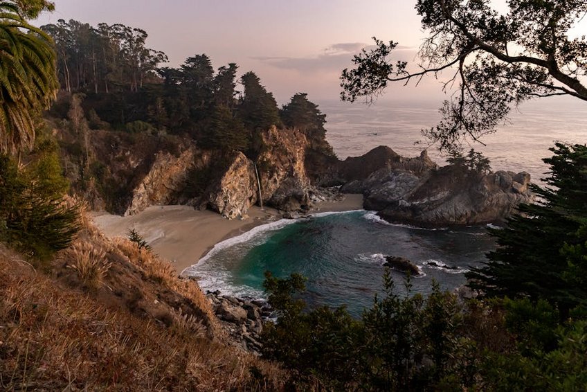
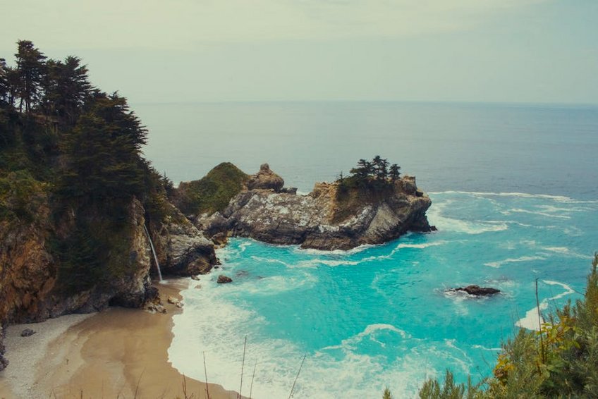
USA Big Sur McWay Falls presents a breathtaking 80-foot waterfall that cascades directly onto a pristine sandy cove along California’s iconic Highway 1 coastline. This natural spectacle sits within Julia Pfeiffer Burns State Park, offering visitors dramatic ocean vistas, accessible hiking trails, and year-round photographic opportunities against the Pacific Ocean backdrop. Our guide delivers essential planning advice, seasonal timing tips, budget considerations, and insider knowledge for maximizing your coastal exploration experience.
Essential Big Sur Information
Big Sur encompasses a 90-mile stretch of Central California coastline renowned for its rugged cliffs, redwood forests, and undeveloped natural landscapes. The region operates as an unincorporated area within Monterey County, maintaining strict development restrictions that preserve its wild character and scenic beauty. Visitors discover numerous state parks, hidden beaches, and world-class hiking trails throughout this protected coastal zone.
What You Need to Know
Before visiting this spectacular coastline, understand these fundamental aspects.
- McWay Falls resides within Julia Pfeiffer Burns State Park, requiring a $10 vehicle day-use fee or California State Parks pass for access to parking and viewing areas.
- The waterfall flows year-round from McWay Creek, with strongest volume during winter rains (December-March) and reduced summer flow creating a delicate mist effect.
- Beach access remains prohibited for safety and preservation reasons, with the waterfall visible only from an overlook platform via a short, paved 0.6-mile roundtrip trail.
- Budget travelers spend $75-150 daily using campgrounds at $35-50 nightly, picnic lunches, and free activities like hiking and beachcombing while prioritizing state parks pass over individual fees.
- Mid-range visitors allocate $200-400 daily for vacation rentals at $150-250 nightly, restaurant meals averaging $15-25 per person, and occasional guided tours or activity rentals along the coastline.
- Luxury experiences cost $500-1000+ daily featuring resort accommodations at $400-800 nightly, fine dining at $50-100 per person, and private tours or spa treatments at exclusive Big Sur properties.
- California State Parks – Julia Pfeiffer Burns State Park
- Big Sur Chamber of Commerce
Key Geological Details
McWay Falls showcases unique coastal geology where freshwater meets saltwater in a dramatic vertical drop. The waterfall plunges from granite cliffs into a turquoise cove that changes color with sunlight angles and ocean conditions. This geological formation results from thousands of years of erosion creating the perfect amphitheater for waterfall display.
California’s tectonic activity continues shaping this coastline, with the Santa Lucia Mountains rising steeply from the ocean floor. The region’s microclimates create frequent fog banks that enhance the mystical atmosphere while protecting delicate coastal ecosystems. These conditions support diverse plant life from coastal sage scrub to towering redwoods just inland.
Historical Context
Julia Pfeiffer Burns State Park honors a respected early 20th-century resident who advocated for environmental conservation. The land previously belonged to the Esalen people, with archaeological evidence dating back 3,000 years along this coastline. European settlement began in the 1860s with homesteaders establishing ranches in these remote valleys.
The iconic Highway 1 completion in 1937 transformed accessibility to this previously isolated region. The waterfall property was donated to California State Parks in 1961, ensuring permanent protection from development. Today, the area maintains its wild character while welcoming over three million annual visitors responsibly.
Planning Your USA Big Sur McWay Falls Trip
Successful USA Big Sur McWay Falls visits require strategic timing between March and May when wildflowers bloom, summer crowds haven’t arrived, and waterfall flow remains substantial. Accommodation reservations should be made 3-6 months in advance, especially for weekend visits during peak season from June through August. Vehicle preparation includes checking tire pressure, brakes, and fuel levels since services are limited along this remote highway stretch.
Budget planning should account for higher costs in Big Sur compared to other California destinations, with limited competition among businesses. Dining options range from casual roadside stops to luxury resort restaurants, while accommodation spans campgrounds to five-star retreats. Always carry cash since cellular service remains unreliable and some establishments don’t accept credit cards.
Your itinerary should balance waterfall viewing with other regional highlights like Pfeiffer Beach, Bixby Bridge, and Point Lobos State Natural Reserve. Allow flexibility for weather changes since coastal conditions can shift rapidly from sunny to foggy within hours. Pack layered clothing regardless of season to accommodate temperature variations between 45°F (7°C) and 75°F (24°C).
Best Time to Visit Big Sur
Visit between April and June for optimal conditions with moderate crowds, comfortable temperatures between 55-70°F (13-21°C), and reliable waterfall flow from spring runoff. July through October brings warmer weather reaching 75°F (24°C) but also thicker fog layers and peak visitor numbers that create parking challenges. November through March offers solitude with temperatures dipping to 45°F (7°C) but delivers powerful waterfall displays after winter rains.
Shoulder seasons in spring and fall provide the best balance between pleasant weather and manageable visitor numbers. Winter visits require checking road conditions since Highway 1 occasionally closes during severe storms causing landslides. Weekday visits always prove less crowded than weekends regardless of season.
Budget Planning and Costs
Understand these three budget tiers for different travel styles.
Essential Preparation Checklist
Pack waterproof layers, sturdy walking shoes, binoculars, cameras, sunscreen, and reusable water bottles for coastal exploration. Include emergency supplies like flashlight, first aid kit, non-perishable snacks, and physical maps since GPS often fails in this remote region. Download offline maps and research restaurant hours since many establishments close early or require reservations.
Secure necessary documentation including driver’s license, insurance cards, and state parks pass if planning multiple park visits. Book accommodations 3-6 months ahead for peak season and 1-2 months for off-season visits to secure preferred locations. Check weather forecasts regularly and have backup plans for rainy days or road closures affecting your itinerary.
Alt: “mcway-falls-big-sur-california-coastal-waterfall”
Top Attractions and Activities
Beyond the famous waterfall, Big Sur offers diverse experiences from coastal exploration to forest immersion. Pfeiffer Beach features unique purple sand and keyhole rock formations perfect for photography during golden hour. Bixby Creek Bridge stands as an architectural marvel offering panoramic ocean views from multiple vantage points along Highway 1 pullouts.
Point Lobos State Natural Reserve presents exceptional wildlife viewing opportunities with sea lions, otters, and migrating whales visible from shoreline trails. Andrew Molera State Park provides extensive hiking through meadows and along the Big Sur River with backcountry camping options. Ventana Wilderness offers serious backpacking adventures into remote mountainous terrain with permits required for overnight stays.
Must-See Highlights
Julia Pfeiffer Burns State Park encompasses more than just the waterfall, with additional trails leading to canyon overlooks and historic sites. The Waterfall Overlook Trail remains fully accessible and paved, suitable for strollers and wheelchairs with minimal elevation gain. Early morning visits provide the best lighting for photography while avoiding midday crowds that gather after 10 AM.
Pfeiffer Big Sur State Park features the popular Buzzards Roost Trail offering 360-degree views of the Big Sur River Valley. This 2.5-mile moderate hike gains 800 feet elevation through redwood groves to a spectacular panoramic viewpoint. The park also offers swimming holes, picnic areas, and nature center programs throughout summer months.
Partington Cove requires a moderate half-mile hike down to a historic landing where bootleggers once operated during prohibition era. The tunnel through coastal rock emerges at a secluded cove with excellent tidepooling opportunities during low tide. Combine this visit with nearby McWay Falls for a full day of coastal exploration.
Hidden Gems and Local Favorites
Garrapata State Park offers two miles of coastline access with less crowded trails through wildflower-covered bluffs during spring. The Soberanes Canyon Trail climbs through redwoods to ridge views while the coastal bluffs trail provides dramatic ocean vistas. Parking remains limited so arrive early to secure spots during weekends.
Sand Dollar Beach presents the largest unbroken sandy stretch in Big Sur, perfect for picnics, beachcombing, and watching surfers navigate the waves. Located south of Lucia, this day-use area requires a steep staircase descent but rewards with spectacular views and relative solitude. Check tide charts before visiting since high tide significantly reduces beach access.
Coastal Hiking Adventures
The Ewoldsen Trail at Julia Pfeiffer Burns State Park offers a moderate 4.5-mile loop through redwood canyons with ocean vistas. This less-traveled path gains 1,600 feet elevation through diverse ecosystems with interpretive signs explaining local flora and fauna. Allow 3-4 hours for this rewarding hike that complements waterfall viewing.
Pfeiffer Falls Trail recently reopened after reconstruction, featuring a gentle 1.5-mile roundtrip to a 60-foot waterfall nestled in a redwood canyon. This family-friendly hike includes bridges, stairs, and interpretive panels about the 2008 Basin Complex Fire recovery. Combine with the Valley View Trail for additional perspective on the landscape.
Practical Travel Information
Big Sur’s remote location requires careful transportation planning since public options remain extremely limited. Most visitors arrive via personal vehicle, with rental cars available from Monterey (45 minutes north) or San Luis Obispo (90 minutes south). The nearest major airports include Monterey Regional (MRY), San Jose International (SJC), and Los Angeles International (LAX) for international travelers.
Accommodation ranges from primitive camping to luxury resorts, with limited availability driving early booking requirements. Dining options concentrate around major landmarks with fewer choices in remote sections, though general stores provide basic supplies. Cellular service remains unreliable throughout most of Big Sur, making advance planning and offline resources essential.
| Accommodation Type | Features and Locations | Price Range (USD) |
|---|---|---|
| Camping | Pfeiffer Big Sur, Kirk Creek, and Limekiln State Parks with basic amenities and stunning natural settings | $35-50 nightly |
| Budget Lodging | Riverside campsites, Big Sur Lodge, and Deetjen’s with shared facilities and rustic charm | $150-250 nightly |
| Mid-Range | Glen Oaks Big Sur, Fernwood Resort, and Big Sur River Inn with private baths and restaurant access | $300-500 nightly |
| Luxury | Post Ranch Inn, Ventana Big Sur, and Alila Ventana with spa services, fine dining, and panoramic views | $600-2000+ nightly |
